HIMAPS
HIMAPS is a platform for browsing, exploring and interacting with digitized historical maps.

Contributors
HIMAPS is all of us
Our contributors 3
Thank you for supporting HIMAPS.

About
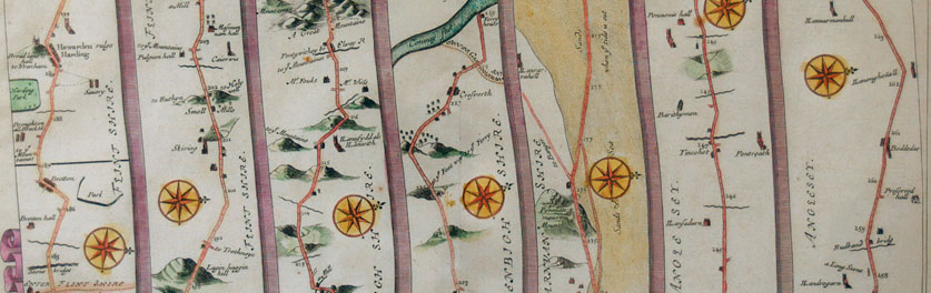
Immerse yourself in the endless world of digitized historical cartography with HIMAPS. Become a time traveling tourist and trace the journey of early travel writers, reading extracts from their accounts directly on the map. Interact with the map elements to navigate through territories, and learn about the evolution of urban and rural spaces throughout history. Add notes and connect materials to create enriched, interactive maps that bring historical research to life.
HIMAPS is a set of tools for cultural heritage professionals. It has the power and flexibility to allow for a wide scope in education and is easily accessible for the general public.
For data curators:
Organize and manipulate your data easily with an intuitive interface: link, georeference and tag 2D and 3D resources, complying with W3C linked data standards. Select related materials to export and make them available to your audience as a comprehensive package. Highlight and complement onsite exhibitions by making them available online. Tailor your key content to your primary target groups. Interoperable with existing data management systems.
For researchers and scholars:
Use the centralized interface to seamlessly access resources across institutions. Select assignment materials, share and comment with your students in real time. Enrich your research with the visualization tools to place it in geographic and temporal context. Lock time or space and create your own thematic maps. Show the evolution of the territory, systems and networks as the geopolitical situation changes throughout history.
Use the centralized interface to seamlessly access resources across institutions. Select assignment materials, share and comment with your students in real time. Enrich your research with the visualization tools to place it in geographic and temporal context. Lock time or space and create your own thematic maps. Show the evolution of the territory, systems and networks as the geopolitical situation changes throughout history.
For the general public:
Discover and explore historical maps without entry level barriers, diving beyond the surface of the drawn territory to navigate through time and space. Follow the steps of travelers in their itineraries on the map, or choose your own parameters and enjoy the discovery of the road on your own terms. Learn about the relationship between locations, objects and historical figures. Edit the maps with notes, images and related materials, save and share them.
Non exhaustive feature list:
- Text and image annotation
- IIIF support
- Georeferencing support
- Linked data
- Clear interface to connect resources and visualize relationships
- Curate and export materials for classroom assignments
- Manipulate 3D models and integrate them in 2D spaces
- Create 3D spaces to visualize the 3D scans in context
- Interoperability with data management systems
- Single interface to access resources across institutions
Get in touch for more information and how to get involved. HIMAPS is in preproduction stage and you can help to make it grow.